
Drone-Based Geospatial LiDAR Acquisition for Data-Driven Decision-Making
1,280,000 points per second and 0.5cm range accuracy. Aerial, handheld and mobile scanning.
At Numu, we employ advanced drone-based LiDAR (Light Detection and Ranging) and GIS (Geographic Information Systems) technologies to support fire prevention, land restoration planning, vegetation management, and environmental resource analysis. Leveraging survey-grade sensor payloads, our aerial platforms generate high-density point clouds and precision elevation datasets capable of revealing fine-scale surface features otherwise obscured by canopy cover or rugged terrain.


Large area coverage capabilities
Numu’s operational efficiency allows us to acquire data across large project areas at scale, capturing up to 750 acres of survey-grade LiDAR per day. This rapid acquisition reduces field time requirements, minimizes environmental disturbance, and accelerates project delivery. Our workflow includes rigorous ground control integration, geodetic corrections, and quality assurance protocols, ensuring consistently reliable datasets suitable for regulatory compliance, engineering modeling, and scientific analysis
How Drones Use LiDAR to Map the Earth

LiDAR — short for Light Detection and Ranging — is a cutting-edge remote sensing technology that uses light in the form of pulsed lasers to measure precise distances between a sensor and the Earth’s surface. These pulses, often exceeding one million per second, record highly accurate elevation data and create detailed 3D models of the terrain, vegetation, and built features. When deployed on a drone, LiDAR technology allows Numu to capture dense, high-resolution data over rugged or remote terrain that would otherwise be difficult to survey on foot. Each laser pulse reflects off the ground, vegetation, or structures, and the sensor measures the time it takes for the signal to return. This information is converted into a point cloud — a rich, three-dimensional dataset that forms the foundation for accurate mapping and analysis. At Numu, these LiDAR-derived datasets are used to support fire prevention planning, forest health monitoring, erosion modeling, and restoration design. The resulting maps and models empower tribes, agencies, and land managers to make informed, data-driven decisions that protect ecosystems and promote sustainable land stewardship.
Using LiDAR to Protect & Restore the land
LiDAR technology is a powerful tool used by professionals across disciplines — from land managers and environmental scientists to wildfire specialists, tribal resource teams, and conservation groups. At Numu, we use this technology not just to collect data, but to serve a greater purpose: restoring balance between people and the land.

199 acres of dense vegetation scanned with a drone LiDAR unit for a land development project

Accurate contours generated from the surface of the 3d point cloud with an average vertical accuracy of 1.95 cm
Applications for Drone LiDAR
Fire Prevention & Management
-
Fuel Load Assessment: Measure vegetation density, canopy height, and biomass to identify areas at high risk for wildfire.
-
Firebreak & Control Line Mapping: Generate high-resolution terrain models to plan effective and safe fire control lines.
-
Post-Fire Analysis: Evaluate burn severity, erosion potential, and vegetation recovery to guide restoration and mitigation work.
Forest Health & Vegetation Monitoring
-
Canopy Structure Analysis: Identify tree height, crown spread, and canopy density for forest inventory and habitat modeling.
-
Species & Health Classification: Integrate LiDAR with multispectral imagery to assess tree health and detect stress or disease.
-
Carbon and Biomass Estimation: Quantify carbon storage and biomass for sustainability and carbon credit projects.
Land Restoration & Environmental Planning
-
Topographic Modeling: Create detailed elevation and surface models for watershed restoration, replanting, or erosion control.
-
Hydrologic Flow & Erosion Modeling: Map drainage patterns to design resilient landscapes and mitigate flooding or sedimentation.
-
Cultural Landscape Mapping: Document historical and cultural land features with precision while preserving sensitive sites.
GIS Integration & Resource Management
-
Baseline Environmental Mapping: Build foundational geospatial databases for ongoing monitoring and resource management.
-
Infrastructure Planning: Support transportation, energy, and communication projects with precise ground and elevation data.
-
Change Detection: Compare LiDAR datasets over time to monitor environmental impacts, forest recovery, and land-use change.
Tribal & Community Resilience Projects
-
Wildfire Risk Modeling for Tribal Lands: Combine LiDAR, GIS, and traditional ecological knowledge to create proactive fire prevention strategies.
-
Habitat and Species Mapping: Support conservation efforts for culturally significant species and ecosystems.
-
Community Safety Mapping: Produce elevation and vegetation models to plan defensible spaces and emergency access routes.
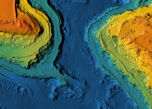
Watershed & Floodplain Modeling
-
High-precision terrain mapping using LiDAR reveals subtle elevation changes that affect water movement.
-
Supports wetland restoration, and climate resilience planning.
-
Enables tribes, agencies, and conservation groups to protect water resources and design sustainable infrastructure.
